Connoisseur’s delight…door to freedom...
If you are not averse to any of these -
Spiti Valley came on my radar a couple of years back while researching some exotic driving holidays in the Himalayas. I was instantly taken in. Ladakh had been on my travel list for over seven years (since the time the populace had not even heard about it), but seeing the swarm of casual tourists thronging to it since the release of 3 Idiots, I decided that it had to be Spiti that I must visit this time around, before the hotels over there too started dishing out thalis!
Spiti, which means ‘the middle country’, is the land of ragged and snow capped mountains that reach out to the clear deep blue skies. Here, in the cold desert, trees are scarce and the moonscape expansive. Spiti is the land of several perennial rivers - Spiti, Pin, Chandra - whose gurgling sounds will soothe you in the night and whose ferocity will awe you when you travel alongside them in the day time. Ah, and not to mention the placid, azure blue lakes like Chandra Taal, Nako, Dhankar. The observer would also be struck by some of the most beautiful canyons and the most unusual clay and rock formations along the river bed and in the mountains. The continuity of the landscape is only broken by numerous waterfalls and glaciers, including one of world's largest non-polar glaciers - Bara Shigri.
For the spiritual seeker, Spiti is home to some thousand year old Gompas (Buddhist Monasteries) and Tibetan art. There is also the mummy of a monk who meditated to death. It's a place which continuously resonates with the chants of Tibetan Buddhism (principal religion) and keeps you in a trance like state. The place also boasts of the world's highest motorable and inhabited villages. A place where lucky few can still find fossils in the valleys or manage to sight Snow Leopards, Ibex, Red Fox, etc. Finally, it is the beautiful people of Spiti who lend the valley its divine soul. These people, despite the harsh environment and poor living standards, are jovial and courteous. They live in match-box styled white coloured houses with lungtas fluttering from their rooftops and speak Bhoti and Hindi languages.


With no dark clouds around, the shutter release button was busy for most part of the journey. Even before it was noon we had encountered two road blocks thanks to some road widening work being undertaken by the Border Roads Organisation (BRO). In stretches where the BRO is active, the roads are excellent. Around noon we reached a place called Khab which marks the confluence of Spiti River and Sutlej River. The view was simply breathtaking. The point of confluence almost looked like the moment when two Sumo wrestlers collide! At this spot the road curves in to a steel bridge, built over the point of confluence, and leads onto a road built through a small semi-circular cut in the mountain (see picture). This is a spot worth spending a few minutes at to marvel at nature’s beauty and man’s zeal for conquest.


There is a German Bakery nearby which serves an assortment of pastries, cookies, breads and other delectable items. We decided to give it a miss and instead treated ourselves to vegetable Momos and Sea buckthorn tea at the hotel. Wah! For dinner we had Tibetan bread and butter.


From here we reached Kaza (3,660 metres), administrative headquarter of Spiti, which would be our abode for three nights. Kaza is the largest of all towns in Spiti (about 1,200 souls!) and has a bustling market place (selling everything - from items of daily need to curios for visitors like us – we purchased two Thangka paintings from here), bus-stand, petrol pump, hospital, and other facilities befitting a regional headquarter. Kaza also serves as the base for a number of mountaineers / trekkers who converge from all over the world to explore the Spiti Valley. In Kaza our home was Sakya Abode, the most popular hotel in the town (located next to the Kaza Monastery) – there is a beautiful array of white Stupas (Chortens) down the road from here. Tsering, the soft-spoken host of Sakya Abode, updated me on Chandra Taal lake, the route to which (a trek which begins from Kunzum La) had been closed for several days owing to heavy snowfall. The trip was getting unlikelier with each passing day as even efforts to clear the road were to no avail – glacial and mountain snow would slide and block the route again!

The Langza monastery was a quaint place where an old priest went about his prayers – reading scriptures and beating a drum simultaneously, unmindful of the visitors. We lighted two lamps after a brief chat with the priest and also took some pictures with his consent. He later offered us tea. There were a few farms scattered about the village, wherever a flat ground could be found, which were cultivated through ingenious ways of irrigation. These were the only sources of green to the eye. Dharamveer informed us that bulk of the farming is of Peas. He also told us that during the winters when temperatures dip as low as minus 30 degrees Celsius, the villagers largely prefer to stay indoors, living upon the supplies collected during the few months of summer.
From Komic we offered a local man Karam Singh a ride in our vehicle. He was a resident of Hikkim and in return offered to show us the ruins of an abandoned Tangyud monastery and some caves. On the Komic – Hikkim route we saw the snow laden Shila Peak (6,132 metres) popping out its near perfect triangular head from behind the brown arid mountains. A little beyond Hikkim village, we parked our vehicle on the road and started descending on a steep incline by foot. Karam Singh told us these old caves were once used for meditation. He initially lured us by saying it’s a small walk – but then I should have known better that at an elevation of 4,500 metres, small walk for a mountain dweller would mean a laborious and breath-sapping effort for a Mumbaikar! We finally gave up as it seemed just too distant and the descent was steep. We then walked up (a easy hike this one!) to the abandoned monastery which was built overlooking the Kaza village (thousands of feet “straight” below) on one side and a valley and canyon on the other sides. The view afforded from the ruins was worth all the effort. Karam Singh informed us that the monastery had been abandoned many years ago due to acute water shortage following an earthquake (a stream had changed its course). On the way back, Dharamveer showed us a stone which he found amidst the rubble at the monastery. It had some sacred Buddhist words inscribed on it!
Day 5, Kaza – Kye – Kibber – Tashigang – Kaza: Today again we would be touring the highest villages of the world. After yesterday, our lungs were primed for it. Our first destination was the Kye Monastery (also spelled Ki / Kee / Key; 4,150 metres), which is the biggest monastery and Buddhist learning centre in Spiti Valley. The Kye monastery complex is a closely packed congregation of white houses built on a hillock overlooking the Spiti River. It is also known as Little Tibet.
Inside the monastery, a monk showed us some 800 years old Thangka paintings, murals, musical instruments and several carefully preserved manuscripts – many of which were brought centuries ago from Tibet. Once here, people should also visit the upper floor / terrace of the monastery for a 360 degrees view of the valley and lungtas strung from ornately decorated pillars.


Kibber village was larger than all the villages we had seen in the last two days with about hundred houses. In the precincts of Kibber monastery I met a group of people from Maharashtra who had tried visiting Chandra Taal Lake. They informed me that the trail was packed with snow and that any attempt to walk would make the person slip and end up 10-15 feet away! Even though I knew during all these days that going to Chandra Taal would be a long shot, this bit of news killed the last vestiges of hope that were still embedded in my heart. Later in the night Tsering confirmed that Chandra Taal would not be possible and so we decided to visit the Pin Valley for our last sojourn.
Day 6, Kaza – Kungri – Sagnam – Mudh – Kaza: As is said, what God taketh with one hand, He giveth (sometimes more) with the other! That in short is the sum and substance of Day 6. Little did we realise, when we woke up, that for the first time we would get to experience the true spirit and culture of the inhabitants of Spiti in all its splendour and finery!


Day 7, Kaza – Losar – Kunzum La – Batal – Chatru – Rohtang Pass – Manali:
 |
| Komic |
- living at an average altitude of 4,250 metres in a cold desert;
- travelling on narrow (single lane), gravel and water filled roads winding through the Himalayas, which stare thousands of feet down into a violent river, and where road blocks due to landslides and snowfalls are as common as the day and night;
- living without newspaper and telecommunication network (save for BSNL) in a place unscathed by modernity;
 |
| View of Spiti Valley from Kye Monastery |
 |
| Tabo Monastery |


I discovered all of this and more during my seven day Trans Himalayan safari. Join me below on this journey through the middle land that is sure to leave an imprint on your mind and impel you too to embark on one…
About the place…
 |
| Kaza |
Located along the Indo-Tibetan border, the district of Lahaul & Spiti is the largest in the North Indian State of Himachal Pradesh. It has been a forbidden land for most part of its history. The land route from Manali is barely open for three-four months a year, while the route from the Capital city of Shimla (which is open year round) takes two days to reach Spiti Valley. For most part of the year the region is covered in snow. Temperatures in winter drop to as low as minus 30 - 35 degrees Celsius and rains are minimal. Consequently, the region is very sparsely populated; with some villages having only a handful of "souls" (that’s what the Government boards read over there. Population: 50 souls)! Unlike Ladakh, it has no airport and suffers from little documented history. It is precisely these factors that lend the place its mysticism and make the joy of discovering its unrivalled beauty indescribable.
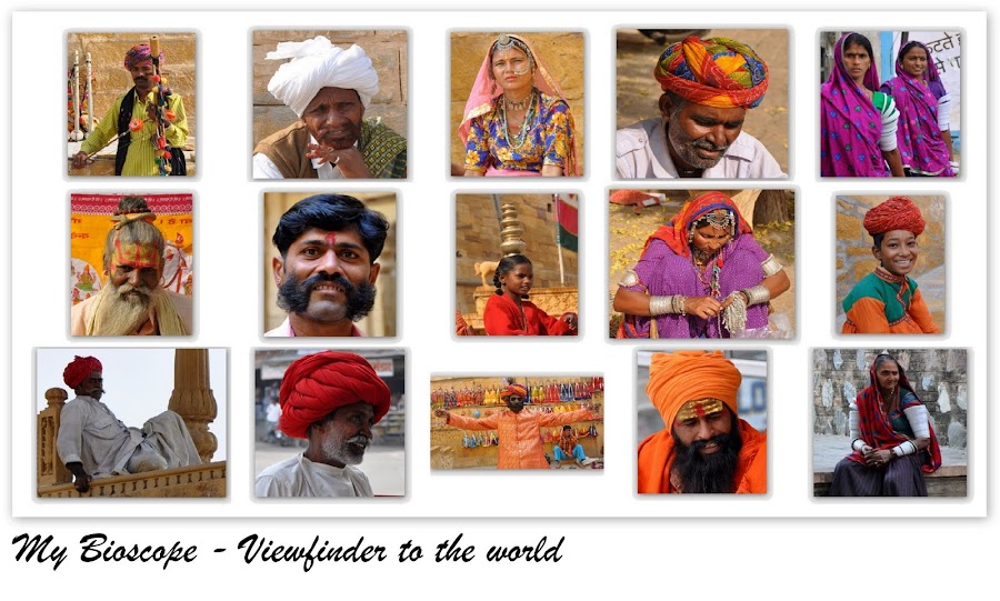
For a slide show of complete set of pictures of People & Culture, please click HERE.
The Trans Himalayan odyssey begins…
Our safari was originally slated to start from Manali through the famed Rohtang Pass that serves as a gateway to the Lahaul & Spiti district. However, as luck would have it, owing to snowing in early June, both the Rohtang Pass and Kunzum La had been closed for vehicles. The day we reached Delhi (we were expecting the route to open in a day or two) we received news that some hapless people, who had been stranded in Spiti for 10 days, had to be airlifted, gulp! After some quick deliberations with Vishesh Shourie of ‘Incredible Spiti’ (an organisation that specialises in providing adventure solutions for Spiti - more about them later) we decided to change the itinerary. We would now enter Spiti via Kinnaur district by starting from Shimla and driving for two full days along the meandering Sutlej River to reach Tabo and finally exit through Manali. The two mountain passes would have “hopefully” opened by the time we were ready bid Spiti goodbye! While this upset the economics, the good part was that we would now get to see both ends of the valley.
I begin below from the time we were introduced to our driver cum guide Dharamveer.
Day 1, Shimla – Narkanda – Reckong Peo - Kalpa: With barely four hours of sleep behind us in the beautiful city of Shimla (whose Wodehousian charm instantly transports one back to the days of the Raj), we were ready to embark on our journey. The Manager of the Royale Oaks Hotel (Lakkar bazaar) introduced us to our driver cum guide Dharamveer, a man of Nepali descent and medium built. The fact that he was also a Buddhist would prove to be invaluable on this trip.
The day was beautiful, skies clear, and a gentle breeze was wafting through the air carrying with it the sweet scent of pine trees. We purchased plenty of plums and other fruits from a roadside vendor (selling a cornucopia of fruits from local orchards) on the highway. They were dirt-cheap (compared to Mumbai), sweet and enough to last us for the next seven days. As we were driving along roads lined with apple orchards and soaking in the verdant pine filled vistas, the weather decided to get ominous. Dark clouds were hovering above us and threatening with their roar. The moment we got off the vehicle, to have lunch at a restaurant in Narkanda, the clouds screamed “bakra” (scapegoat) and opened their bellies upon us. Wind got chilly and gusty, light had faded and I started to worry about photography as Dharamveer promised stunning views ahead. He also told us that this would probably be the last place where we would get good Punjabi food. We ate to our heart’s fill and moved ahead.
 |
| Dark clouds near Narkanda |
 |
| Rampur Bushahr |

We were now driving on the old Hindustan – Tibet road, traversing deep canyons, ridges, and some startling rock formations with the Sutlej River flowing in all its ferocious grandeur thousands of feet below. The landscape was barren. I have been to mountains before. But never before had I felt so vulnerable. The roads (NH 22) were extremely narrow and to call them roads would be a misnomer. They were merely paths or tracks for the most part. Roadblocks are as common here as day and night.
 |
| Sutlej River |
Being summer time, we were treated to some gushing waterfalls in the Kinnaur district created by the melting snow and as the sun set, we passed the famed Nathpa – Jhakri hydel project, the Kharcham – Wangtoo hydel project and finally the Baspa hydel project (phew!) to enter Reckong Peo, the administrative headquarters of Kinnaur district. Located about 10 Kms from Reckong Peo is the quaint town of Kalpa (approx. 250 Kms from Shimla) where most motorists retire for the night. Hotel Apple Pie in Kalpa has some well appointed rooms that, the manager promised us, also offered the best views of the majestic Kinner Kailash (also called Kinnaur Kailash; 6,350 metres) mountain peak. The peak is revered equally by Buddhists and Hindus of the land.
 |
| Kinner Kailash at Sunrise |
Day 2, Kalpa – Nako – Khab - Tabo:
The best time, they say, for landscape photography is sunrise (and sunset) as the soft and gradually changing light weaves its magic upon the sky-scape. Unfortunately the sun rises at 5:15 AM in these parts! Waking up on the dot on a cold summer morning, I set aside the thick blanket and drew the curtains. What I saw left me awestruck. The Kinner Kailash was there right before me (well almost). The sun was rising from behind the mountains, giving their rims a nice golden glow. As the town was waking up, women went about their chores and we enjoyed our morning cuppa with eyes transfixed on the mountain peak. It seemed as if God had ordained timelessness upon this town.
The best time, they say, for landscape photography is sunrise (and sunset) as the soft and gradually changing light weaves its magic upon the sky-scape. Unfortunately the sun rises at 5:15 AM in these parts! Waking up on the dot on a cold summer morning, I set aside the thick blanket and drew the curtains. What I saw left me awestruck. The Kinner Kailash was there right before me (well almost). The sun was rising from behind the mountains, giving their rims a nice golden glow. As the town was waking up, women went about their chores and we enjoyed our morning cuppa with eyes transfixed on the mountain peak. It seemed as if God had ordained timelessness upon this town.
 |
| Kalpa at Sunrise |
 |
| Khab - Confluence of Spiti River (left) and Sutlej River (right) |
With no dark clouds around, the shutter release button was busy for most part of the journey. Even before it was noon we had encountered two road blocks thanks to some road widening work being undertaken by the Border Roads Organisation (BRO). In stretches where the BRO is active, the roads are excellent. Around noon we reached a place called Khab which marks the confluence of Spiti River and Sutlej River. The view was simply breathtaking. The point of confluence almost looked like the moment when two Sumo wrestlers collide! At this spot the road curves in to a steel bridge, built over the point of confluence, and leads onto a road built through a small semi-circular cut in the mountain (see picture). This is a spot worth spending a few minutes at to marvel at nature’s beauty and man’s zeal for conquest.
From here onwards we gradually began to notice the changes in terrain. Rocky mountains gave way to brown and grey sloping mountains. The valleys were wider (enabling human settlement) and skies far more bluer. There was not a hint of green around, save for a few scattered farms cultivated by some enterprising people. Tufts of white clouds were strewn hither thither like pieces of cotton.


Drive to Tabo Along Side Spiti River
 |
| Nako Lake |
Around 1.00 PM our vehicle turned into Nako village, a hamlet known more for its lake. We had lunch at Lovon Hotel (by no means shady) and then sauntered toward the lake. I was momentarily dumbstruck by the serenity of the place. Not a leaf seemed to move. The clear reflection one could see in it of the surrounding environment told me how much the residents of this place cared about keeping the environment clean.
 |
| Himalaya from Nako |
 |
| Tabo Monastery |
Grudgingly we returned to our cars to resume our journey onward to Tabo. Beyond Nako lies the village of Sumdo, which formally announces your arrival in to Spiti Valley. On the way, Dharamveer pointed towards Kaurik peak from where a motorable road (now used largely by defence personnel) leads up to Indo-Tibet border and which used to serve as an important trade route in ancient times. Around 4.00 PM we reached Tabo (3,250 metres), which seemed like an oasis in this other wise arid land. With a population of 150 odd souls, Tabo is a quiet village that owes its popularity to the venerable Tabo Chos – khor monastery, which was founded in the year 996 AD! Driving past the monastery, we turned rightward on the helipad (which was built many years ago to receive His Holiness 14th Dalai Lama for the inauguration of the new monastery) and reached Tashi Khangsar Hotel, our abode in Tabo. The hotel was sandwiched between the monastery and a rocky mountain. Needless to say it afforded good views.
Since the day was still good, we decided to tour the Tabo monastery after relaxing for a few minutes. The new monastery was closed in the evening so we spent most of our time exploring the old one. As we entered we saw a few young monks playing near the guest house and waving out to us. The vintage of the monastery becomes quite evident from its charming structures which are built from sand and mud. Set against blue skies and brown mountains, the precincts of the monastery have a uniquely magical feel. The inside of the monastery is a virtual treasure trove of millennium old murals, Thangka paintings, scriptures and sculptures. After marvelling at the work of art I realised why the Chos – khor monastery is also referred to as the ‘Ajanta of the Himalayas’. Unfortunately, photography is strictly prohibited inside the old monastery.


Tabo Monastery
There is a German Bakery nearby which serves an assortment of pastries, cookies, breads and other delectable items. We decided to give it a miss and instead treated ourselves to vegetable Momos and Sea buckthorn tea at the hotel. Wah! For dinner we had Tibetan bread and butter.

Day 3, Tabo – Dhankar – Lahlung - Kaza: In the morning we first visited the new monastery. Dharamveer requested a senior monk to show us around and he willingly obliged. Grander than the old monastery, the place was a picture of calm. As we stood in silence, the monk gave us interesting pieces of information on the Buddhist religion, the works of art inside and of course The Dalai Lama – the single most revered person in the region. From here we proceeded toward the nearby caves (phukpas) for which we had to hike a bit from the main road. The rarefied air in Spiti Valley makes one breathless at the slightest of exertion. These caves are used by monks for meditation and one of them also has an elaborate mural inside. From here one gets a bird’s eye view of Tabo village and the surrounding scenery.
 |
| Tabo Village, As Seen From Caves |
 |
| Dhankar Monastery Complex |
Today’s first major destination was Dhankar (also spelled Dhangkar / Dangkhar; 3,900 metres). The Dhankar monastery, a near 1,000 year old symbol of Vajrayana Buddhist architecture, is one of the 100 most endangered monuments in the world (as recognised by the World Monuments Fund)! It is constructed on a 300 metre high ledge in a rocky mountain near the confluence of Pin and Spiti rivers. An architectural marvel of its time, today owing to its age and an earthquake that struck the region in 1975, it is in the imminent danger of collapsing. There is also a dilapidated fort (there are some wonderful murals inside its rooms), that once enveloped the entire complex, the remnants of which can be explored by hiking. As a matter of fact, it is this fort which lends the place its name. Dhankar literally means – fort on a cliff! Dhankar incidentally also has a lake, but for which one needs to hike for about an hour or two.


 |
| Confluence of Pin & Spiti Rivers |
 |
| Dhankar |
The entire complex, and the mountain on which it stands, has an almost fairy tale like beauty when viewed from a distance. From the monastery one can see some crazy natural rock / sand formations on the left, the Dhankar village scattered in the centre, and vast expanses of the valley on the right where the clean blue waters of Pin River merge into the muddy brown waters of Spiti River. The colourful Lungtas (prayer flags), strung from the poles, and swaying in the foreground add an air of spirituality to what is one of nature’s finest pieces of work.
At some distance away, on the opposite mountain, is the new Dhankar Monastery. Behind this new structure is a guest house where one can get a wide variety of food to eat. We decided to have our lunch here. Being in a Tibetan frame of mind we ordered Thukpa and fried rice for lunch. The gallery of the guest house is like a viewing deck overlooking the valley and a photographer’s paradise. I took several wide angle shots of the monastery and snow clad mountain peaks while waiting for the lunch to be served.
 |
| Canyon, Spiti River and Lahlung Village |
Motoring along the main road we took a diversion from Lingti village on a gravel road that supposedly would take us to Lahlung (also spelled Lalung / Lhalung). This journey, beside the Lingti valley, provides you with sights of some of the finest canyons and rock formations in India (some of which, atop the mountain, appear like the ramparts of a fort!). Half and hour into the drive we realised we were on the wrong path as we had reached a point beyond which it was impossible to drive. We turned back and returned to Lingti where some enquiries threw up an alternate road which finally did manage to take us to Lahlung.
 |
| En Route Lahlung |
 |
| Lahlung Monastery |
The Lahlung monastery, also about a millennium old, is fondly called the Golden Temple (Serkhang) since it has statues (supposedly 1,200 years old!) which are plated in gold. A senior monk showed us around the place and gave us details on the history, murals, artefacts, sculptures and other symbolisms. Photography is permitted inside the monastery as long as you don’t fire your flash gun.

Outside the monastery, as we began chatting with the monk and some rural folks (mostly giggling women), we realised that they couldn’t even place Mumbai and Kolkata on the map of India! Few had even heard of these places! Yet they were simple, charming and alluring people, gracious enough to invite us to join their tea party. Most of them work on the National Rural Employment Guarantee Act (NREGA) projects and knit sweaters during their free time. The old monk (no pun intended) treated us to fine lemon tea and ladoos. The lemon tea was far better than what one gets in an upmarket urban joint. It is also here that I met the dancing girl (see pictures). In reality she was not dancing, merely being shy and trying to cover her face as I tried to photograph her thereby creating the illusion. While parting the folks placed a violet coloured flower around our ears which they believe to be a good luck charm. I was truly overwhelmed by their hospitality.


In these parts I have realised, under the tutelage of Dharamveer, that a simple gesture like greeting juley (a kind of namastey in local dialect), with folded hands and slight bow, can help break the ice with locals.
 |
| Chortens in Kaza |
 |
| Rock & Clay Formations Near Kaza |
|
| Rock & Clay Formations Near Kaza |
Day 4, Kaza – Langza – Hikkim – Komic – Kaza: I was eagerly looking forward to today as I have always wondered what life is like at great mountain heights. Our destinations for today were some of the highest inhabited and motorable villages in the world - all located at an altitude of 4,200 metres and more.
 |
| Langza - Chau Chau Kang Nilda Peak |
Our first stop was Langza (4,200 – 4,400 metres, 148 souls), the fossil capital of India. Several aeons back when the Indian sub-continent arrived from the Southern Hemisphere (Gondwana) and collided with the Asian mainland, its impact led to the creation of the world’s highest mountain range, the Himalayas. A by-result of the impact was the fossilisation of several marine and other creatures at the seam. Langza is one such place which was witness to that event and as testimony has several fossils to show - scattered in the nearby nullahs and valleys. While many have now disappeared due to looting and illegal sales, the villagers assured me that a keen eye could find one even today in the various nullahs here and beyond. A drive towards Langza brings up a huge statue of Gautam Buddha (built at the edge of a hillock) on the horizon with the towering Chau Chau Kang Nilda peak (6,300 metres) in the backdrop. This statue and a 500 year old monastery are the principal attractions of Langza. There is also a fossil centre (Chadua) in Langza, which we unfortunately could not visit.
 |
| Langza |

The Langza monastery was a quaint place where an old priest went about his prayers – reading scriptures and beating a drum simultaneously, unmindful of the visitors. We lighted two lamps after a brief chat with the priest and also took some pictures with his consent. He later offered us tea. There were a few farms scattered about the village, wherever a flat ground could be found, which were cultivated through ingenious ways of irrigation. These were the only sources of green to the eye. Dharamveer informed us that bulk of the farming is of Peas. He also told us that during the winters when temperatures dip as low as minus 30 degrees Celsius, the villagers largely prefer to stay indoors, living upon the supplies collected during the few months of summer.
 |
| Stuffed Snow Leopard |
From here we proceeded further towards Komic (also spelled Comic / Gomic - 4,275 metres, 114 souls), passing Hikkim village on the way – there is a shortcut from Hikkim to Kaza and hence we decided to tour Hikkim later. We could catch a sweeping 180 degrees panoramic view of the snow laden Himalayas from these places. The old Komic Gompa (monastery) situated at about 4,587 metres is perhaps world’s highest monastery and is about nine centuries old. Our entry into the old monastery, quite small and non-descript in comparison to others, was greeted by the horrific sight of a dead snow leopard’s stuffed body, its bulging eyes ogling at us! Spiti Valley, in particular Pin Valley National Park, is home to snow leopards and several other endangered animals. After offering our obeisance here, we went to the grand new monastery, which also has several rooms for the monks to stay. The outside of the monastery was painted quite attractively using a combination of four-five colours and had ornately decorated windows. Here too the folks graciously offered us some tea (seemed like an official merry making drink of the Spiti Valley!) and chatted for a while. One of them also played the flute for us, crafting an almost mystical setting – tea, music, Buddhism, Himalayas!


Komic
 |
| Drive through a cold desert (Shila Peak on the right) |
From Komic we offered a local man Karam Singh a ride in our vehicle. He was a resident of Hikkim and in return offered to show us the ruins of an abandoned Tangyud monastery and some caves. On the Komic – Hikkim route we saw the snow laden Shila Peak (6,132 metres) popping out its near perfect triangular head from behind the brown arid mountains. A little beyond Hikkim village, we parked our vehicle on the road and started descending on a steep incline by foot. Karam Singh told us these old caves were once used for meditation. He initially lured us by saying it’s a small walk – but then I should have known better that at an elevation of 4,500 metres, small walk for a mountain dweller would mean a laborious and breath-sapping effort for a Mumbaikar! We finally gave up as it seemed just too distant and the descent was steep. We then walked up (a easy hike this one!) to the abandoned monastery which was built overlooking the Kaza village (thousands of feet “straight” below) on one side and a valley and canyon on the other sides. The view afforded from the ruins was worth all the effort. Karam Singh informed us that the monastery had been abandoned many years ago due to acute water shortage following an earthquake (a stream had changed its course). On the way back, Dharamveer showed us a stone which he found amidst the rubble at the monastery. It had some sacred Buddhist words inscribed on it!
 |
| Hikkim |
 |
| Kye Monastery Complex |
|
| Kye Monastery Complex |
 |
| View From Kye Monastery |
Inside the monastery, a monk showed us some 800 years old Thangka paintings, murals, musical instruments and several carefully preserved manuscripts – many of which were brought centuries ago from Tibet. Once here, people should also visit the upper floor / terrace of the monastery for a 360 degrees view of the valley and lungtas strung from ornately decorated pillars.
 |
| Kye Monastery |
In the prayer hall of new Gompa, four monks were engrossed in a prayer and we stood there for a few minutes observing their rituals. Their singing and music elevated us to a trance like state. I was shaken out of my trance by Dharamveer who prodded me to resume our journey towards Tashigang. It was only upon reaching the vehicle that I realised the reason for his impatience. Seated in the backseat was an octogenarian monk with a walking stick in one hand, beaded holy thread in the other and a slightly hunched back. He had not been to Tashigang for years and saw through us an opportunity to visit it now. He planned to stay there for a few days. Most monks travel to neighbouring monasteries on foot, trekking the Himalayas. However, his age obviously forbid him from doing so. Which also made me wonder how would he comeback since few vehicles ever visited Tashigang.


Tashigang is a remote village with about five - six homes and is known more for the La Darcha fair grounds. The monastery here is about a millennium old and housed in a small mud structure with thatched roof. The area around Tashigang also serves as pasture and breeding place for horses. Declining an offer for tea from the local folks, we motored ahead towards Kibber admiring the Chau Chau Kang Nilda peak, which is visible from here as well.

 |
| Tashigang |
 |
| Kibber |
Kibber village was larger than all the villages we had seen in the last two days with about hundred houses. In the precincts of Kibber monastery I met a group of people from Maharashtra who had tried visiting Chandra Taal Lake. They informed me that the trail was packed with snow and that any attempt to walk would make the person slip and end up 10-15 feet away! Even though I knew during all these days that going to Chandra Taal would be a long shot, this bit of news killed the last vestiges of hope that were still embedded in my heart. Later in the night Tsering confirmed that Chandra Taal would not be possible and so we decided to visit the Pin Valley for our last sojourn.
Day 6, Kaza – Kungri – Sagnam – Mudh – Kaza: As is said, what God taketh with one hand, He giveth (sometimes more) with the other! That in short is the sum and substance of Day 6. Little did we realise, when we woke up, that for the first time we would get to experience the true spirit and culture of the inhabitants of Spiti in all its splendour and finery!
 |
| Mudh Village |
Pin Valley is connected to Spiti Valley by a solitary bridge (Attargu) across Pin River. Most of the valley has been declared as the Pin Valley National Park, spread over an approximate area of 675 sq. Km. It is a natural habitat for endangered species like the Snow Leopard, Himalayan Ibex, Bharal, Red Fox, Snow Cock, Lammergeier, Woolly Hare, etc. Since the terrain is mountainous, tracking these creatures is only possible by exploring the vast expanses of the valley on foot with the aid of experts. I, however, managed to spot a scrambling Red Fox, a Lammergeier in flight and a few mountain goats on our way back in the evening.
 |
| Kungri Monastery |
Our principal destination for the day was the ancient Kungri Gompa (also spelled Ghungri / Khungri; 3,520 metres). It is the main centre of Nyingmapa order of Vajrayana sect of Buddhism in Spiti and widely popular for the sword dance performances of Buzhens. Upon reaching the monastery we learnt that a two day cultural fair was on over there. Today, being the second day, the Lamas (monks) would be performing a number of Cham dances (also spelled Chham) for the dignitaries and residents of Pin Valley. Interspersed with these were folk dance performances by the students of the region and some comic acts by juvenile monks to lighten up the mood. We reached at about 10.00 AM, in the nick of time, as the proceedings were about to begin…

The Cham dance is a form of ancient Tibetan masked dance, which is performed in groups to the beat of traditional Tibetan instruments. It involves rhythmic circular movements, slow and minimal movements of the hand and feet, and periodic displays of energy when the Lama swirls 360 degrees in a flash by jumping in the air. While most dances appear the same (atleast to the layman), they vary in the design and type of various symbolic items used – masks, ornaments, costumes, head-gears, use of certain articles like daggers, Tibetan drums, etc. - each having its own meaning and interpretation. The dances are used to narrate different stories / incidents from the religious texts and to preach lessons. One cannot help but be awed by the sheer vibrancy of colours on display. These dances, while they appear simple, require lot of practice and co-ordination since the masks have no eye – holes!


The performances had the audience in gasps and raptures. This cultural affair provided me with plenty of opportunities to photograph the mood, the facets, the culture and colours of the people of Spiti in an atmosphere of candour and gaiety. The only regret was that we could not see the beautiful monastery from inside since it was closed on the occasion for visitors. The loss of Chandra Taal was squarely behind me.


 |
| Sagnam Village |
As the event was drawing to a close, around 4.00 PM, we decided to checkout some of the other villages of Pin Valley such as Sagnam (the largest), Mikkim and Mudh (remotest). After spending some time admiring the scenery from Mudh and chatting with the locals (no tea this time) we returned back to Kaza. En route, we offered an Israeli trekker a ride in our vehicle. He was on a long visit to India exploring the Himalayan regions of Sikkim, Nepal, Varanasi, Rishikesh, Haridwar, Spiti and was soon headed for Ladakh. He was as much mesmerised by the place as we were.
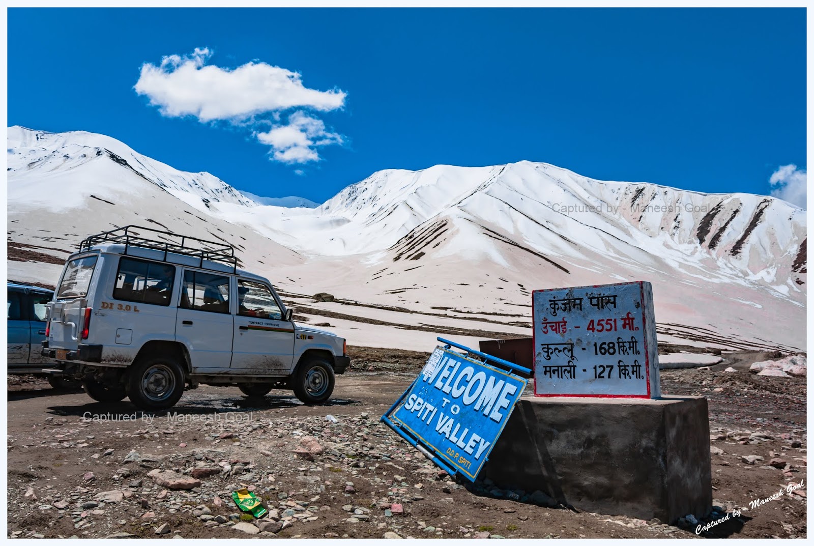
Day 7, Kaza – Losar – Kunzum La – Batal – Chatru – Rohtang Pass – Manali:

The thing about Spiti is that it’s not over until it’s over. The drive from Kaza to Rohtang Pass is perhaps one of the most picturesque in India. Since we had to traverse some 200 odd Kms in a single day, we left Kaza at about 7.00 AM. The route is notorious for unexpected stoppages due to landslides / snow-slides as well as traffic jams at the Rohtang Pass. Hence, it was imperative that we reached Chatru by 4.00 PM.

By 9:30 AM we were at the Losar check-post (also spelled Lossar; 4,079 metres). Most visitors prefer to use Losar as their base for the trek to Chandra Taal Lake, which begins from about 18 Kms from here. Natives here were discussing how the unexpected snowing and the resultant closure of the route had affected their business. As such the valley attracts tourists for mere three-four months and any loss of day can mean heavy losses for the tourism industry.
In about an hour’s time we were driving through the Chandra Valley and as we neared Kunzum La (Kunzum Pass), we realised that we were now completely surrounded by snow – like a boat in the middle of an ocean. At about 4,590 metres, the area around Kunzum La is the highest in the region. The white clouds near the peaks of Chandra and Bhaga mountain ranges appeared like smoke billowing from chimneys. The Chandra River was now our companion (it goes on to meet Bhaga River near Tandi to form Chenab River) and the roads were lined with snow up to 10 feet high! From a distance we could see one of the world’s five largest non-Polar glaciers, the Bara Shigri Glacier – like white and grey lava flowing down a mountain.


En Route Kunzum La
 |
| Kunzum La |
At the Kunzum top there is a temple, which Chortens, dedicated to Goddess Kali. We spent about 15 minutes here – photographing the spectacular mountain peaks and the Bara Shigri Glacier. There were also quite a few herds of sheep and lamb grazing around the place on whatever little grass could be found. This entire region is a hotbed of small and large glaciers – Bara Shigri, Chhota Shigri, Kulti, Shipting, Pacha, Chandra, Ding Karmo, Gyephang, Bolunag, Shili, Shamundri, etc. It is believed that the Chandra Taal Lake was formed many years ago by the Bara Shigri Glacier due to geological disturbance in the region.
 |
| Kunzum La & Glacier |
After praying at the temple for a safe journey we moved on toward Batal. Barely 30 minutes in to the drive and we encountered a serious roadblock. An earthmover was clearing mounds of snow that had slid on to the road. We decided to make the most of this opportunity and asked Dharamveer to click some clichéd pictures of us – playing in the snow against the backdrop of Bara Shigri Glacier.


The drive from here onward, though not steep, was very difficult. The roads, which would intermittently cross river beds, were full of small rocks and often streams of water from the melting snow would cross violently over them making it difficult for Dharamveer to navigate the vehicle over invisible rocks. Occasionally the wheel would get stuck. Other times the vehicle would simply bounce and swerve. Our anxiety was however alleviated by the sight of glacial ponds, frozen river beds and waterfalls. The dappled light falling on the valley and refracting in the air gave the sky an almost cosmic appearance.


Chandra River, Glacier and Glacial melt near Batal
 |
| Batal |
Around 12.45 PM we reached Batal where we stopped to have tea. The chilling weather clearly warranted it. Batal is all of three – four dhabas (food joint) where most motorists, after a strenuous drive, relax to have lunch. Further, we reached Chatru (3,385 metres) around 3.00 PM where again we halted for some refreshments. The weather from here onward was similar to the one we encountered on the Shimla – Kalpa drive. Skies were overcast, it almost seemed like 7.00PM, and a light drizzle was on incessantly.
 |
| Rohtang Pass |
The drive to Rohtang Pass was a slow, winding drive upwards. A climb made difficult by the heavy fog, which had reduced visibility down to a few feet. I would have my heart in my mouth every time Dharamveer would negotiate a turn, as neither the valley nor the bend in the road were visible. Dharamveer had to call upon all his experience, accumulated over 20 years of driving in these mountain passes, to reach us safely to Manali. Around 5.30 PM we were finally at the Rohtang Top. The place was crammed with innumerable shops that sell refreshments in the day time. A lot of tourists visit Rohtang Top to experience snow (mostly for the first time) and shamelessly leave behind a litter of plastic, a sight which I could not digest. Finally after an hour of descent we reached Manali and with it came to an end a journey which I can only describe as an odyssey.
“At last they entered a world within a world – a valley of leagues where the high hills were fashioned of the mere rubble and refuse from off the knees of the mountains…. ‘Surely the Gods live here,’ said Kim, beaten down by the silence and the appalling sweep and dispersal of the cloud-shadows after rain. ‘This is no place for men!”
– Rudyard Kipling writes about Spiti in his book ‘Kim’.
 |
| Spiti |
Travel tip...
 |
| Treacherous Roads |
The best time to visit Lahaul – Spiti is during the summer months of June – September. One could start either from Shimla or Manali depending upon his convenience and / or the mood of Rohtang Pass. Since one would be living at great heights, it is advisable that he consults his physician before embarking on the journey. As one may have realised from the travelogue, having the right vehicle and the right man at the helm of affairs is perhaps the most critical aspect of travelling to Spiti. It is hence my suggestion that you contact people who are absolutely trustworthy and are experienced in providing advice in the region. While it is possible to book a cab from the Manali taxi stand, you wouldn’t know beforehand about either the quality of the vehicle or the driver. I have always planned my own trips and done the bookings myself. But, as I researched about the place, I realised that this one trip had to be done differently.
Having availed of their services, I would not hesitate one bit to recommend the guys at ‘Incredible Spiti’ – customised travel and adventure solutions provider for the Spiti region. The success of my trip owes a great deal to Vishesh Shourie and his team's meticulous planning, good selection of vehicle and hotels and a continuous drive to ensure that we had a great time. It was also wonderful to see how they handled a last minute change in itinerary owing to the closure of Kunzum La. Without them we would have been probably stuck.
You could give them the itinerary and budget and they will design a trip around it. Alternatively you could just book the vehicle and / or hotels through them or merely ask them for trip advice!
Lastly, I would suggest that you keep your budgets flexible by at least 30 - 50% to meet contingencies like change of route, health problems, need to overstay owing to closure of roads, inclement weather, etc.
Go, attain nirvana!
Go, attain nirvana!

Copyright Maneesh Goal. All Rights Reserved. Write to me at mybioscope.blog@gmail.com


56 comments:
nice write-up with fantastic pictures!!
Crisp n direct dil seh. loved the pics n the write-up - Vimal
Buddy I am sure it was a Nice trip. we are a group of 4 persons planning this next year ...possibly on Bike...we would love your comments/suggestion/ advise.
Hi Prashant...thanks so much for visiting my blog and leaving a comment. I am sending you a mail with some suggestions. Lemme know if you need anything specific. Also please confirm if you've received the mail.
Hats off 2u...!!!
dewaprasad@yahoo.com
@Dewa Prasad: thanks so much for reading this post and appreciate your comment.
Nice Shoot
Thanks Mr. Anonymous :)
Great post and pictures! Thanks for sharing your experience at Spiti. I'm planning to volunteer with Spiti Ecosphere in May and will be spending a month there. After reading your travelogue, I am even more convinced that I'll love spending time there :)
Cheers,
Shivya
Thanks so much Shivya. Hope you have a great time in Spiti along with doing some wonderful work with Ecosphere!
Thanks Manish for sharing your exp. I am planning to visit spiti during first week of June with my family. My only concern is I will be traveling with my 4 year old daughter.Do you see any issue traveling with children?
Thanks for sharing your exper. Pl let me know if it is feasible to travel to lahaul spiti in April.
@swetal: Thanks so much for writing in :) I really don't see any issue in taking your 4 yr old daughter along. However, I would advice you to take it easy during the trip with adequate rests i.e.
1) Do not undertake very long journeys in a day
2) Avoid gaining a lot of altitude in a day.
3) Follow the itinerary described above, since starting from Shimla gives you a lot of time to acclimatise. Preferably have 2 buffer days to spend time in Kalpa / Sangla should you feel the need.
4) If need be consult a general physician before embarking on the trip.
During my trip too I had seen people with kids.. so prima facie it should be an enjoyable one for your daughter :) So have fun and wish you a safe journey!
@ans: Thanks for your compliment :) In case you wish to travel in April then you will need to travel via Shimla as the Manali route would be closed. Also be prepared for an adventurous time since the place would be draped in snow and weather can be inclement at times. I would suggest you consult the local taxi guys before you embark on the trip!
Thanks for the extremely well written article and the accompanying photos. Just whetted my appetite to visit these places on a driving holiday. I am planning a trip in July this year - I will definitely get in touch with Mr. Vishesh Shourie. Any other tips from you? Could I use this forum to ask if any like-minded person would like to join. My email is sushil@mardas.com
Sorry, could not mention my name in the comment above. I am Sushil Marda, and I'm from Kalimpong in Darjeeling District, West Bengal.
Dear Sushil... many thanks for those words of appreciation :) I have highlighted some general tips in my comments above. However, if you need any specific help, I would be glad to be of assistance.
Yes, you can contact Vishesh and he will help you out with the trip in whatever capacity you need his assistance for. As for a companion, you can ask Vishesh if he knows any like minded who would be travelling around the same time as you. You may also want to check out forums like TripAdvisor & IndiaMike to search for a partner.
All in all, hope you have a great trip. Travel safe and stay healthy :) All the best!
Great stuff! Hope to be there in september!
Sujoy
@Sujoy: Thanks so much for stopping by and commenting :) Hope you have a great trip :)
man! you have noooo idea how much this helped me :) we are four girls planning a trip to spiti on the 8th of this month, and we have chosen the same route, going via simla and returning via rohtang! your post really helped me clear a lot of my doubts, though i wonder if i should forward it to my less adventures friend who already has her heart in her mouth and needed a lot of convincing:) great post and great pictures.... do have any more suggestions please please pass them on......
@Mayuri: Thanks so much for your words of appreciation. I am glad you liked the stuff. In case you have also read my comments above, then I have generally covered most of the general suggestions. But here are some more -
The trip is adventurous, but there is nothing really to be worried about. When I was there, I had seen people in the age group of 3 years to 75! Just ensure that you hire a good vehicle (since the terrain is bad)…it shouldn’t be rickety and it has an experienced driver at the steering wheel. Weather can play truant, so keep 1-2 days as buffer. You might need to extend your stay if there is a roadblock. The air over there is thin, so don’t over travel in a day and keep the first day in Spiti for rest.
Also en route Tabo from Kalpa, there is a diversion which leads to Gheun. I would suggest you visit that place as well. There you can see the mummy of an old monk. A place which I missed was Chandra Taal (since the route was closed). You will need to halt at Losar from where you can go on a trek to the lake. You could even hire mules if any of you finds it difficult to walk. You can even camp for a night at the lake. There are people providing this service in Losar.
Have a great trip and feel free to contact me should you need any specific information.
we do plan to do chandratal, and hope to camp by the lake as well... provided the road is not blocked. we are hiring a cab from himachal taxi and if the driver is a local i think it should not be a problem. thanks for the help, and keep those posts coming:)
very good and thak you very much
manas banerjee.
ITINERARY
27/09/2011 Howrah - [ train Hwh –Kalka mail ]
28/09/2011 Train
29/09/2011 Kalka - to Simla [ train shibalik express] stay at simla
30/09/2011 simla – to Sangla [ by car/jeep]
01/10/2011 Sangla – Chitkul –kalpa [stay]
02/10/2011 Stay at Kalpa
03/10/3011 klapa – to – Nako [lake] –Dhankar[lake] –Kaza
04/10/2011 Stay at Kaza [for Kibber and Ki village]
05/10/2011 Kaza to Chandertal then Batal [stay]
06/10/2011 Batal to Manali to Mandi
07/10/2011 Mandi to Simla
08/10/2011 Stay at Simla [ extra date]
09/10/2011 Simla to Kalka [Train]
10/10/2011 Train
11/10/2011 Howrah
IS IT OK?
PLEASE HELP
I AM GOING ALONG WITH MY WIFE AND 3YR OLD CHILD, ARE THERE ANY PROBLEM ? .
I WANT TO HIRE A CAR FROM SIMLA , WHAT WILL BE THE BEST OPTION FOR ME AS PER AS CAR IS CONCERN.
TOTAL HEAD [1+1+1]
__________________
MANAS BANERJEE
@manban: Thanks so much for writing in. I am surprised your itinerary does not include places like Tabo, Komic, etc. I would suggest you adopt a day wise itinerary similar to mine...you can drive directly from Shimla to Kalpa, stay there overnight and drive next day to Tabo. The journey from Kalpa to Kaza would be very tiresome.
Do let me know if you have any specific queries.
Thank you we completed our trip nicely. Beauty was out of our imagination . Thank u for your information and help.
From
manas banerjee
This is really nice. I really want to go to Lahul Spiti for long time. Could you please let me know any good organizer who can help me in a 7/8 days trip? Or you have your own contact? My contact is bneloy@gmail.com
Is Nov end good time?
Regards
Neloy Banerjee
@Manas: Nice to hear that you had a great time in Spiti. Congratulations on a successful trip.
Am really glad know that the article was of use to you. Cheers!
@Neloy: I have replied to you by mail. Do let me know if you need any further info.
Maneesh. loved the post and the photographs. I am planning leh trip next year and you suddenly got me excited about Spiti as well. Too much to do and too less a time.
@Mayank - Thanks so much for those kind words :) I guess you will need to toss a coin - both places are equally beautiful!
Me too visited lahul- Spitti during Sep 2009. We had a nice drive and we stayed inside the lahul village in a primary health centre. Such a beautiful place and had a nice drive too..Really it was an amazing experience.
Good comments and pics too.Me too had some similar pics
@Chitra: Thanks so much for dropping in and posting a comment. Am glad you liked the stuff and pleased to know that you had a very enjoyable trip to Spiti.. congratulations! Would love to see your pictures of Spiti!
Excellent write up. This trip log has everything a Spiti enthusiast is looking for. This post has helped my planning my trip next year (June 2012)!! A million thanks mate :) And last but not the least, really loved those photographs, keep clicking!
@Ajiz: Thank you so much for those extremely kind words... I am glad the post was useful to you...makes my day :)
Hope you have a very enjoyable trip to Spiti!
Well written. Great pics.we will use this blog to plan our trip for June 2012.
Vivek Athavale
Thanks so much Vivek...am glad you found the post useful. June second half is a good time to visit...but the weather is always fickle so keep your fingers crossed and plan accordingly.
Maneesh...great informative article! Can you tell me how much did your whole trip cost? I'm trying to budget for my own trip to Spiti this year and this will help a lot! Thanks!
Hey Bro!
Ur write up is awesome and because of that i am able to convince my frnds to visit to the spiti...
we are plannning for 1st week of october but the total days i wanna give to spiti is just 7 days. is that enough as my frnds also want to stay at manali for longer so i have to divide the trip.
Bro!! gr8 pics around and tons of thanks for this write up.....
Vivek , Mumbai
Dear Vivek,
Thanks so much for those kind words. I am glad that the report helped you guys. I guess 7 days should be sufficient in Spiti. I presume you'd be taking the Manali route - so two days for the Manali to Kaza and back commute and 5 days within Spiti is workable. This is of course assuming you don't lose any day due to fickle weather. If required you can cut down on a place or two to relieve yourself of the continuous stress of travelling. Feel free to ask more.
Hi! I myself am a traveloholic and have already been to Leh and know what you meant when said now flooded with people. I too have been wanting to go to Lahaul and Spiti but my mother is 65 plus and my daughter is just 2, don't know whether travelling for me to this place will be possible in next year? Can you suggest what budget would be needed and above all are there comfortable hotels en route? Can you plz reply on my mail:
verasingh@gmail.com
Would like to know more abt this journey seriously. Would love to hear from you soon!
we are 5 person group.we want to travel kinnar and lahul spiti at 23rd,october 2012 to 2nd november 2012 this year.
Can you plz reply on my mail:
banirecord@gmail.com
Would like to know more abt this journey seriously. plz help me.
name:bani chowdhury
Its a unique and modern place and there are some person live but some want outing and enjoying.
Desert Safari
Desert Safari Dubai perfect place for the couples too where you can enjoy every thing there is no disturbance .
Looks like you are a specialist on this because you just made it so easy to be with you, motivated me to learn more on the subject!Regards
Nursery School Franchisee - Little Millennium
Manish, am off to spiti this june end. Dropped you an email with few questions. Let me know.
Did i tell you - your photographs have blown me away. Cant wait to get there.
Hey, I want to visit Spiti Valley in December. Will it be a good time to be there??
@Nehali: Thanks so much for visiting my blog. The route via Manali would be closed during December (you will need to take the Shimla route, but I don't know how safe it is in winters) and as such Spiti would be extremely cold (sub zero temperatures) and the place draped in snow. Unless you are looking for that kind of an experience, I wouldn't recommend travelling in December. July-September is the best period to visit, as you can enjoy the topography.
Awesome Tour Itinerary...
Get cheapest domestic vacation packages and international vacation packages.
dear maneesh
thanks a million for a lovely blog and sharing your travel experience.
infact me and my wife are going planning a trip to spiti in july, we are from mumbai, we are leaving mumbai on 17th july and coming back on 28th july, we have already booked our flite tickets to and from chandigarh.
your blog has got me charged up and im eagerly looking forward to this trip.
i wish to get in touch with you to help me plan my trip, i will write a mail to you.
and if someone here is willing to join us for the trip, it will be nice.
thanks a million once again
sunil
Hey can you please give me tips again on my email as I will be visiting on 19th July from Manali route. Thanks a ton for this blog it helped me a lot to understand about the place. And I have contacted incredible spiti for my travel needs. Thanks again bro.
narenn86@live.com
Thank you Maneesh. A wonderfully detailed diary and some great pictures. I stumbled upon your blog while researching for our trip through the same road in Mid-Aug/ Early Sep 2016. We would be self-driving, so that adds a layer of further uncertainty! However, it's set in our hearts so we must! While following your diary, I am wondering: Is it better to enter through Shimla-Kalpa for better acclimatisation, a 3-night stay at Kaza to explore the Pin Valley leisurely, be ready (in some way!) for the rigours of Losal and Chandratal (God willing and Body permitting!) and then dropping into Manali? About 7-10 days: Chandigarh-Shimla-Kinnaur-Spiti-Manali-Chandigarh. Fly in and out of Chandigarh from Mumbai. Does this seem workable to you? About 6-8 people, all adults 50+, more or less active and fit. Sorry..a lot of questions. Thanks again for your wonderful diary. Shall show it around and share. arindam.paperboat@gmail.com
Dear Arindamji,
Thank you so much for visiting my blog. I am glad you enjoyed the post and the pictures. I appreciate your spirit and zeal to explore Spiti.
In my opinion, you've got the itinerary bang-on. I would have personally recommended the same. Traversing through the Shimla-Kinnaur-Spiti route exposes you to a different experience altogether. Your ascent would be gradual and the scenes along the way will keep you mesmerised. You've also budgeted sufficient number of days to take care of any contingency, which is a good thing. Weather and road conditions over there are fickle. Let me also forewarn you that the drive from Shimla to Kalpa is a very long one (nearly 12 hours) and the road ain't a smooth one. You could consider taking a break for a day or two at a place like Sangla or Kalpa to rejuvenate and then proceed further.
Also, on the way to Tabo from Kalpa, there is a diversion which leads to Gheun. I would suggest you visit that place as well. There you can see the mummy of an old monk (not the bottle one).
Since you are all active and fit, you should be able to pull off the trip. Would only suggest taking some necessary precautions, such as:
1) Do not undertake very long journeys in a day. Take adequate rests during the day. Go for small walks daily.
2) Avoid gaining a lot of altitude in a day.
3) Stay hydrated. Avoid drinking / smoking. Eat healthy. Eat some garlic.
4) If need be consult a general physician before embarking on the trip. You may also want to ask him about Diamox, a tablet which aids acclimatisation (we had taken a 3-day course of it during our recent trip to Ladakh).
Do let me know if you have any further queries. I wish you best of luck for the journey.
Maneesh Goal- Let me know if my inputs are needed here anytime. Will be more than happy to guide people and help them plan. So happy to see that you have been able to help people with this write-up and valuable information. Cheers
Vishesh Shourie
Wow that was incredible..thankyou so much for sharing..just wanted to know about the cost..approximately how much it'll cost for a person
Dear Prity,
Thanks so much for visiting my blog. Am glad you liked the post. The cost would be a function of your itinerary, choice of vehicle and hotels. I suppose, for an itinerary like the one above, it would cost 35 - 50K per person, ex-Manali (assuming 2 people). I do not have a precise estimate, but it would be safe to budget around this much.
Before going to anywhere guidance is really important .The way you wrote about blog that’s really great i like this blog.Thanks for sharing this with us. Spiti Valley is a great tourist destinations located in Himachal Pradesh.
Post a Comment
Thank you for visiting My Bioscope and I appreciate your valuable comments.
Please do mention your Name at the end of the message.